Stuc a' Chroin and Ben Vorich

Stuc a' Chroin and Ben Vorich
Showing posts with label Ochils. Show all posts

Wednesday, 5 August 2020

Wednesday 3 June - Glen Bee and Hill of Kinpauch (Kinpauch Hill on OS Maps)

A few days earlier we had enjoyed a fine traverse of the hills above Glen Sherup and from our lunch spot on the broad ridge above the Broich Burn, between Frandy and Burnfoot Hill, we could see that Upper Glendevon Reservoir was very low, perhaps even lower than during our last long spell of drought conditions in the summer of 2014. We knew that a closer look could be combined with a walk through Glen Bee to Hill of Kinpauch which we hadn't climbed for a couple of years, so that was our plan for the next day.

There was no rush, so after an hour or so of walking we paused for early morning tea by the unnamed burn that gently tumbles from a secretive little glen into the lower reservoir  There are many such burns not named on the 1:50 map which are on the 1:25 map but this is not one of them, so I must do a bit of research to see if I can solve these minor mysteries. Swallows entertained us, skimming above the bracken and water, gathering up insects. As always in such a setting it was hard to move on, but move we must.

It's all fairly rough going through heather and bracken to the dam, with only the occasional sheep trod to follow so another stop for tea at a favourite spot was welcome. Glen Bee is part of an old packhorse route and now a fairly popular walk from Tillicoultry to Blackford, home of Highland Spring mineral water. Unfortunately to reach Blackford the very busy A9 has to be crossed so beware. The name Glen Bee is possibly from the Gaelic 'Gleann na Bighe', glen of the post or pillar. Presumably a stone or post marked the route at one time. Perhaps submerged by the reservoir now? Anyone know?

Some delightful walking above the reservoir on a grassy path took us into Glen Bee and so to the watershed, where a farm track begins its descent to Blackford by Glen of Kinpauch and the Braes of Ogilvie. For a time this route follows the Glen Burn on its way to meet the Danny Burn which eventually passes west of Blackford village to join Allan Water. In addition to being the home of Highland Spring since 1979, the beautiful malt whisky Tullibardine is made here. Originally a brewery, the conversion to a distillery was begun in 1947. Highland Spring and the Tullibardine both use water drawn from the Danny Burn.

We were neither going to Blackford nor down to the Danny Burn but staying high, so took time to enjoy the views across Strath Allan to the hills beyond. And enjoy them from a distance was all we could do, sadly, since the five miles or so travelling restriction was still in force.

Then onwards we went through the summer heather which completely covered the narrow path that normally contours round our hill. We both enjoy rough walking like this and it didn't take long to reach the northern slopes leading to the blustery summit. Oddly, for a hill so accessible from Blackford, we have never met anyone else here and today was no different.

After the usual photographs we returned by our outward route rather than over the tops, though we initially set off in that direction before deciding to plunge down the heathery slopes for the path back to Glen Bee.  Another fine and satisfying day in the Ochils.


Note: OS Map names the hill 'Kinpauch Hill' but the glen being "Glen of Kinpauch", we prefer Hill of Kinpauch which I'd guess is the correct local name.


The reservoir wasn't as low as in 2014 but would be a few weeks later


Glen Bee

The track drops into Glen of Kinpauch to Blackford


Leaving the cairn before descending the heather slopes on photograph number 5. Alternatively a return can be made via Craigentaggert Hill over tussocky, trackless terrain which is an enjoyable alternative to retracing steps.


Thursday, 4 June 2020

Friday 29 May - Return

On Thursday Nicola Sturgeon duly confirmed the promised slight easing of the lockdown and hillwalking could resume, with the proviso that you stayed local. No problem for us except to decide which hills to climb.

There were lots of cars parked at Castlehill Reservoir but we hadn't planned to stop there or the Woodland Trust carpark in Glen Devon which in any case was closed. Thwarted, people had parked their cars in small lay-bys and many others were half on verges and half on the road with the typical disregard for others which seems so common these days. They were mostly picnickers down by the river.

At the head of Glen Eagles though, we we were in glorious isolation back among the hills after ten long weeks of exile. Cuckoos welcomed us and have been constant companions on this and our three other days in the Ochils.

Fishing had resumed on Lower Glendevon Reservoir as per lockdown easing although we were surprised to find the boats out rather than anglers on the banks. It was good to see the country make tentative steps back to some sort of normality


From our chosen top we could see patches of snow lingering on Beinn Ghlas and Ben Lawers and other hills further north, all beyond our reach for the moment as was a good photograph given the heat haze.

It was a grand day out over the hills in a very welcome cool south easterly breeze watching the larks soaring, a sight we've missed so much this year. As a bonus Lynne spotted a nest among the tussocks with the young staring skywards, beaks gaped.


Anyone for Tossing the Caber?


All construction has been halted during lockdown except, of course, if it involves a bit more destruction of the Ochils. Four new bigger turbines to be installed.

West Craigs, which we traversed on our way back
It was simply bliss to be back among the hills but crowds of idiots descended on the Loch Lomond area and Glen Coe at the weekend, flouting the guidance on travel, so Nicola is threatening to change this guidance to law. Not sure how that will go down with those of us who've done our best to comply.  

Sunday, 16 February 2020

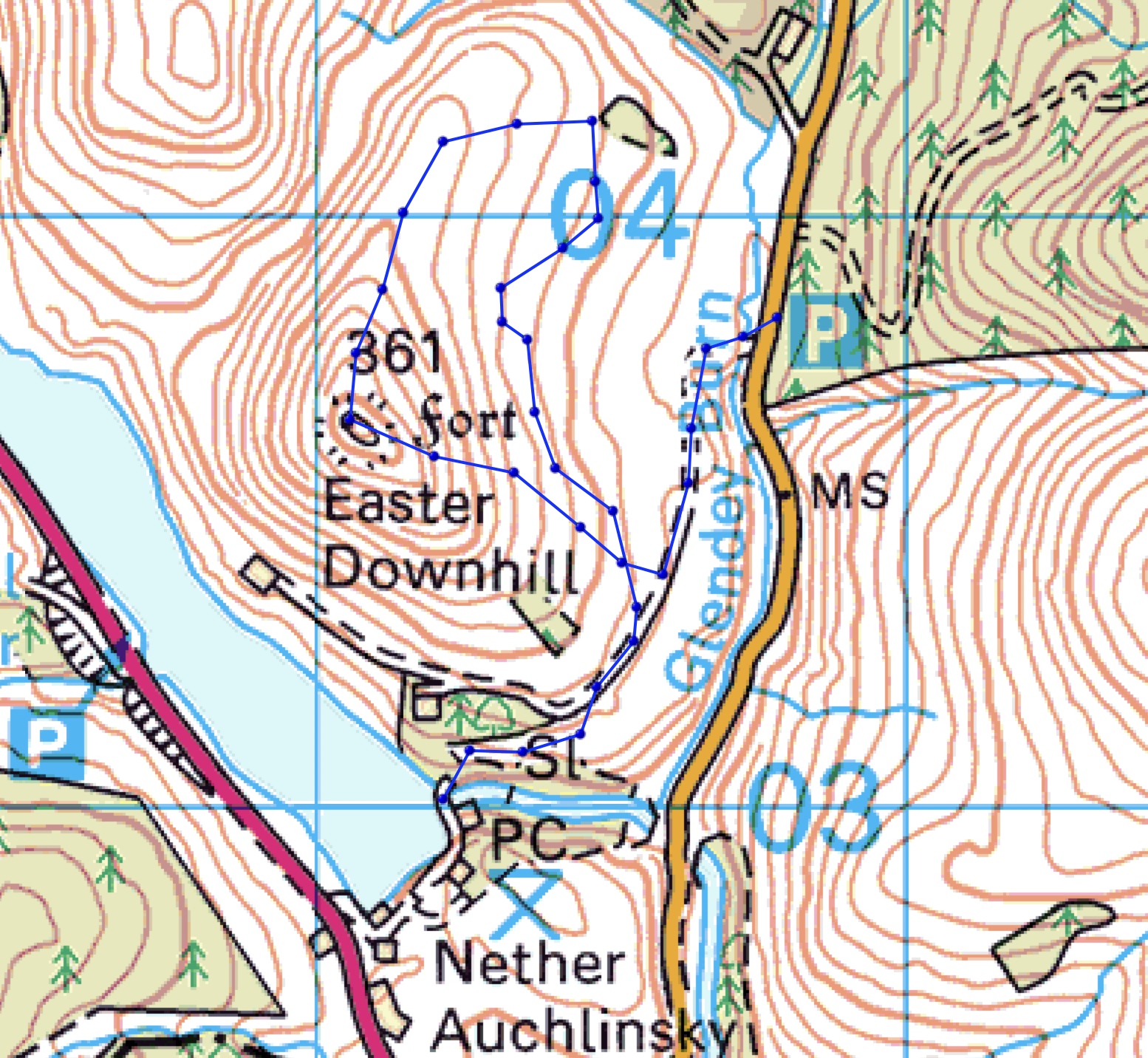
Monday 3 February - Easter Downhill, 361m OS map 58


Easter Downhill from Castlehill Reservoir (February 2019). Castle Hill is an alternative name for the hill. 
A warm balmy Spring day wandering among the hills north of Glendevon village eventually landed us on the 361m summit of Easter Downhill.

That was in 1991 and with us was the latest member of the family: Mist, our Border Collie, rescued six months earlier in a poor state from a farm not far from where we stood. Now healthy and strong, two months later she would climb her first Munros with us on a backpacking trip in Knoydart. That left us one Munro to do, Sgurr Dubh Mòr on Skye which involves scrambling, so we were on our own unfortunately.

Though dry, it was far from balmy when we pulled into the small parking area below Lendrick Hill and, with perfect timing, the forecast rain blew in just as we were putting on our waterproofs. Cameras were stuffed into rucksacks, waterproof (?) covers atta, taken off again to get gloves, car keys dropped in the mud. But no matter, it was good to be out in some rough weather and heading for a top again.

A short walk along the road took us to the farm road to Downhill and the open exposed hillside. The wind battered away at us, sleet showers swept in and just as quickly pushed through, my waterproof rucksack cover blew off, was retrieved, re-attached, blew off again so returned to its zipped pouch. We enjoyed it all.

Lendrick Hill from the top of Eater Downhill.

Castlehill Reservoir  and Seamab Hill 

Distant middle - Whitewisp Hill,  and right Innerdownnie Hill

On the summit, we remembered the day back in 1991, took some photos and Lynne briefly reacquainted herself with the remains of the hillfort, but it was no place to hang about so we departed downwards towards a stand of Scots Pines where lunch could be had in relative calm.

Mellock Hill from our tea break spot. First of the local hills to be threatened by wind farms in early 2002 (I think),  a campaign stopped the development but even more inappropriate locations in the Ochils were chosen instead.
We found a sunny spot with a good view to Mellock Hill and enjoyed a brief halt to enjoy a cup of Lapsang Souchong and a biscuit. Our plan to walk directly back to the farm track was soon abandoned as we sank into the sodden ground. Some may remember that my left Achilles tendon is troubled by wearing boots so I was wearing trail shoes which of course failed to keep my feet dry in such conditions. Lynne's boots performed no better so we ascended some way back up Easter Downhill to escape the worst of the quagmire, dropped to a gate and so to the track.

Heading uphill a bit to escape the bog
The weather was now blustery and invigorating so we decided to continue towards Downhill Farm and have a look at the Castlehill Reservoir dam where we reckoned the overflow would be quite spectacular. The start of the path to the dam is waymarked but obviously not used very much, probably because there is limited parking on the B934 and most people (tourists rather than walkers) use the route near Nether Auchlinsky on the A823.

Approaching Castlehill reservoir with weather closing in again


Plunging to the River Devon to join the River Forth

The photo doesn't capture the overflow's display of power, though a video taken with the iPhone does better.
 
On our return journey we noticed some rusting farm machinery - cultivators - in a field. They had been manufactured by Nicholson of Newark around 1906-1920, perhaps earlier, and unlike old rusting cars found in similar locations their presence didn't jar.


A route by the pines (not the ones where we had tea) looks like an ideal walk on a summer's evening


A nasty chest infection kept me housebound for a large part of January so it was a great relief to
be on a hill again. I did manage to finish my latest model, the Apollo 11 Command and Service Module so the month was not completely wasted.

Our 1991 route as I remember it, minus the Green Knowes Windfarm


Today's route


Sent from my iPhone

Saturday, 20 October 2018

Good intentions...and a bit of a rushed post.


When we returned from our Braemar holiday last month I sat down to write a post summarising the final part of our holiday, but that idea was eventually binned along with a laptop computer and HP printer.  After many years of resisting the temptation we decided to have an iMac, our experiences with Windows being mixed to say the least, and since we have other Apple products it seemed like a logical step. So I told myself anyway. Setting up the new wireless printer was a trial and eventually I resorted to a manual process to get it on the network, all attempts at following Canon's online instructions having proved futile.

Anyway, the transition to the iMac has been painless and with a 4K Retina display our photographs have never looked better.

However, having got to grips with High Sierra I noticed that the installer for the the latest OS, Mojave, had been quietly downloaded to the Applications folder for me but, Apple or not, I'm cautious about new OS releases so it can sit where it is for a while. High Sierra is working just fine thank you. A day on the hill was needed, not more computing.


From Andrew gannet Hill to The Law

It's relatively rare for us to approach hills at the western end of the Ochils from Dollar or any of the other Hillfoot towns for that matter, the Glen Devon starting points being generally quieter and longer. However a change was required, so here we were at the Castle Campbell car park, surprisingly, on our own.

Dollar Glen with its steep gorge of crags and trees is an impressive place but far too gloomy for such a sunny day. So, we took the shorter but no less impressive higher route which traverses via a narrow path above the gorge, the Burn of Sorrow thundering below on its way to join the Dollar Burn. Once in the open we were quickly on top of Bank Hill, locally Dollar Hill, which gave us fine views of the Forth Valley, the Ineos petrochemical plant at Grangemouth standing out above the river mists.

As so often in the Ochils we had no hard and fast plans for the day other than reaching King's Seat Hill summit where options could be considered. We paused at the memorial located at the crash site of three Spitfires which operated out of Grangemouth during WW2. The airport opened in May1939 as Central Scotland Airport and was used from September of that year by 602 Squadron which flew Supermarine Spitfires. Bristol Blenheims and Gloster Gladiators were flown by 141 Squadron and Westland Lysanders by 263 Squadron.

I've never come across any wreckage in the area, indeed knew nothing of the crash at all until the plaque was erected in 2009, though it has been suggested that tiny fragments might be lying around on the hill.

From King's Seat top we headed down almost to the source of the Gannel Burn then up the well trodden grassy path to Andrew Gannel Hill where the decision was made to forgo a trip out to Ben Cleuch and instead, return to the car over Tarmangie Hill, Whitewisp and Sandy Hill. That decided, I confidently descended back to the Gannel Burn to pick up the path from Mill Glen to the foot of Tarmangie Hill. Except of course there is no such path and why I thought there was escapes me. The lapse was of no consequence of course and a slightly wet walk through long grass and reeds brought us to a beautiful flat grassy spot, perfect for an overnight camp, or in our case for lunch in the sun beside the burbling burn. It's always hard to leave such places.

The high tramp from Tarmangie Hill, over Whitewisp and down to the small outcrop on Sandy Hill is a grand one which we haven't enjoyed for a long time although as Lynne observed, it did feel odd not to be turning NE for Bentie Knowe and Innerdownnie from Whitewisp's cairn.

The little outcrop above the steep slopes of Sandy Hill provided good views down to Dollar and the Castle as well as eastwards over the lovely countryside where we live.


Friday 19 October

Over the last 4 years Lynne has been asked by various local history societies to give a talk on her book Beatrix Potter's Scotland - Her Perthshire Inspiration, published by Luath Press, Edinburgh and now in its second edition. This year the talk was in Auchterarder. Some interesting questions were asked and answered, books were sold and signed and a most pleasant evening was had by all.

Plastic Modelling

It will soon be time for me to resume my plastic modelling activities with a build of the Saturn V. My new blog is more or less ready so that I can record my progress and provide technical information on the real vehicle for anyone who is interested. I hope I can complete the model by Christmas because in the New Year I plan to build another Space Shuttle Orbiter, Altlantis. This is a Tamiya model and will be in orbit configuration with payload doors open. I am really looking forward to this project.


Meantime here are a few photos of our day in the Ochils.


Lower slopes of King's Seat Hill showing the 'Banks of Dollar' - the transverse gullies


Castle Campbell 


Ineos


Andrew Gannel Hill


Ben Cleuch from Andrew Gannel Hill

View from the outcrop on Sandy Hill


Saturday, 4 August 2018

Saturday 4 August - A return to blogging - and one last mention of models and space

I finished my last post on 12 June with: "My calf muscle is now completely back to normal so hills - at last." That was optimistic, as a couple of easy walks of five miles demonstrated. Another two and a bit weeks' rest and more physiotherapy was required before I felt ready to venture onto a hill.

By then it was nearly July, not our favourite time for the Highlands, so in perfect weather we walked locally (posts to follow), grew vegetables, enjoyed the garden and I read much about the space programme in the Apollo and Space Shuttle years. I've always been interested in the space programme but at the time there wasn't much to read and no internet for information. Now there are books galore.

Since I'm currently building a model of the Saturn V, Lynne bought me the highly technical Saturn V Flight Manual. This is the genuine article as issued to astronauts by NASA signed by Deke Slayton Director of Flight Crew Operations and Arthur Rudolf, Manager of the Saturn V Programme. In addition she bought me the Haynes NASA Space Shuttle, 1981 onwards (all models) - Owner's Workshop Manual and despite the tongue-in-cheek title it is in fact an authoritative insight into 'the design, construction and operation of the NASA Space Shuttle' by a former NASA engineer. Other Haynes Manuals followed for the Saturn V and  Apollo 13 mission. I also got round to setting up a new blog on model building: 'On Pillars of Fire' at www.pillars-of-fire.blogspot.com. There are no postings as yet, just a header photo which is not visible in mobile view. Progress on the Saturn V build will be recorded on that blog.

On the reading front I enjoyed two books in Stieg Larsson's 'Millenium Trilogy' (Girl with the Dragon Tattoo etc) and am on the final book. Also 'Failure is not an Option' by legendary former Flight Director Gene Krantz, was a fascinating read and I have the equally legendary and, sadly, late John Young's book, 'Forever Young', waiting in the wings.

You'll be glad to read in the post title that from now on there will be no mention of space or models on this blog with all such material being posted on the aforementioned 'On Pillars of Fire'.

Now, walks. I have not posted anything about the walks we've done during this summer - in fact I stopped posting about outings in our local hills some time ago since inevitably there was much repitition. Recently though, it struck me that I wasn't keeping a record for my own interest which is at least as important than whether others find some, or indeed all, of my posts less than absorbing. One hopes some readers get at least something from some of the scriblings but if not, well it can't be helped.

There will be catch up posts later - but here are a couple of photos from a recent walk.


On the Cadger's Yett having started from the Dunning Road - about 4km from this point. John's Hill centre


Edit: Lynne has rightly corrected the above caption. I am not 'on' the Cadger's Yett, but the Cadger's Path which leads to to the Yett.


Thursday, 1 March 2018

Wednesday 21 February - a perfect day

The Frandy Burn was low today so we easily stepped across the ice-free rocks at the usual place and headed out of the shadow and into the sun, eventually following our customary route upwards by the Inner Burn. Once on the broad, gently rising ridge leading to Mailer's Knowe a completely unnecessary sign points to Ben Shee. If you need this sign you probably should be walking in a park.

Someone studying their map and planning a trip here could be forgiven for thinking that there is dense tree cover on these slopes but it's mostly relatively new planting by the Woodland Trust which owns this part of the Ochils. The walking is open with unobstructed views, as you can see below.

The open slopes leading to Mailer's Knowe. Click to enlarge all photos
Despite having walked in these hills regulary for a huge chunk of our lives (I first climbed Ben Cleuch when nine) there are still many nooks and crannies that remain unknown to us. Often these are small glens striking only a few kilometres into the hillsides providing alternative, pathless, tussocky ways, rarely, if ever, used to reach the tops; sometimes no doubt they will prove to be nothing more than short diversions from the day's main objective but either way, I'm sure they will be of interest. They may even prove useful material for that rarest of things of late - a post on this blog.

I've a hankering to explore two of these 'unknown' places in the vicinity of today's walk. They are the two small glens whose burns cradle Middle Hill: Middlehill Burn and the unnamed burn below the western slopes of the hill. We have walked, both in ascent and descent, the third burn which meets this unnamed stream and whose source is just a few metres east of point 442m on the long broad ridge which leads from Skythorn Hill to the road near Backhills.

But back to today's walk.

At the boulder on Scad Hill we considered an ascent of Tarmangie Hill but rejected the idea in favour of Skythorn and a circuit back to the car. Seems to me that we often have this debate with the same outcome.

The final slopes to Scad Hill

The boulder with its frozen moat. A favourite place and favourite isolated boulder.

The walk from Scad Hill by Cairnmorris Hill (a mere bump and off picture). Andrew Gannel Hill ahead, Ben Cleuch distant

It was cold so we moved fast to get out of the wind - as you can see from the above photograph  there's no shelter here - but as we approached the stile and then Skythorn Hill (a minor rise in the picture above) things became more benign.

Tarmangie Hill from near the stile. Typical grassy terrain in the Ochils

We spotted two other walkers, a rare event, as we descended from Skythorn but they had vanished down to Backhills by the time we reached the point on the ridge near the source of unnamed burn mentioned earlier. We on the other hand stopped for lunch, enjoyed some Lapsang Souchong and the growing strength of the sun in our faces. But we had a final hill to cross so eventually stirred ourselves, somewhat reluctantly.

Now, Frandy Moss is a bog but a pleasant one if you know the route through it (and we do) so the last unmarked top of the day was quickly reached via the familiar ATV track. The 500m top is an excellent view point.


From near the 500m point looking to the slopes of Middle Hill (centre) and behind, the long broad ridge of Mailer's Knowe etc with Tarmangie peaking over it

A short distance above the track by the Frandy we enjoyed yet more time sitting in the sun finishing off our food before the lovely walk back to the car. Not a particulary long day (about 12km) but it was indeed a perfect one among our friendly hills.


The 1:50 000 map omits the names of many burns in the Ochils including Middlehill Burn. The route shown across Frandy Moss is not precise


Note: I expect I've posted about this walk before, perhaps more than once. Sorry if it's repetitive!


Saturday, 24 February 2018

Tuesday 20 February - Some hills north of Glendevon

There was a time when Ben Trush (OS Thrush), Green Law, Sim's Hill and John's Hill could be approached easily by the Cadger's Path (Borland Glen), the Glendevon Youth Hostel's small car park providing a convenient starting point. A house now stands on the YH site and the small car park has been absorbed by its driveway. A walk down the busy A823 from Castlehill Reservoir's parking spot and then a loop via the quiet hamlet of Burnfoot is now one of two routes to the former YH start. Apart from the A832 bit it's a pleasant enough walk.

Today though we chose the second option, one which I never imagined walking even in my wildest nightmares: via the appalling Green Knowes Windfarm. Not only did we use the access road but passed under the massive turbines to drop down to the glen. The noise was horrendous, the whole place an abomination. Our intial intention was to cut over Ben Trush's south shoulder into Borland Glen but the turbines are almost as close when in the glen, the noise not much less (or so I thought) so I kept walking up the access road. Lynne was a bit behind watching some roe deer on the other side of Eastplace Burn so was not consulted!

I was wrong about the noise. It was almost unbearable: howling, screeching, whistling, whining, grinding. If you think this is 'green' then you're colourblind. I took a photograph of part of the once lovely route by the wall from Ben Trush's cairn and could have wept.

Passing between two turbines we gained the Cadger's quickly and were soon on the gentle slopes of Green Law, the change in our mood palpable, the feeling of well-being restored.

These are lonely hills, not often visited even from Corb Glen which is easily accessed from the Dunning road. We have been regular wanderers in this area for over thirty years and have watched the wreck shown below turn from a fairly intact turqoise-coloured vehicle to the present heap of rust. It has, as Lynne said, almost attained sculpture status, though it's as unwelcome here now as it was when it first was dumped. There's a second one near Sim's Hill which has been there for about twenty years I think. Why?


It's been a cold snowy winter up here, by recent standards at any rate, and although these modest heights had lost their snow cover, spring felt a long way away in the chill wind. After lunch on John's Hill's sunny slopes, where spring did not seem such a distant prospect, we quickly returned to the glen and the stroll down the grassy path.

A short climb through thick grasses led to a wall which we followed to the small cairn on Ben Trush. We turned to face south rather than look at the first of the turbines straight ahead. The higher Ochils were still holding snow and tomorrow we'd be crunching over it.

60m turbines. A peaceful place, full of memories, trashed.

Pleasant walking from Green Law to Sim's Hill and left John's Hill

Near the Cadger's Yett

Our hills for the following day


Saturday, 21 January 2017

Wednesday 18 January - Corb Law and Corb Glen to above Coul

Corb. 1428 'Crob'. Derivation for this form 'compare Gaelic 'Crob', later 'Crobh', a hand, a claw, possibly referring here to some perceived shape in the terrain. For instance the contours on the north side of Corb Law on OS maps trace the shape of a hand with outstretched thumb and clenched fingers (Angus Watson, The Ochils, Placenames, History, Tradition).

He's correct of course, but we had no knowledge of this when setting out for Corb Glen and Law. Watson does point out that the hand shape is not easy to see on the ground and the reference may be a 'tantalising coincidence'. We need to go back.

Can you see the hand?


A locked gate, the top festooned with barbed wire, gave the distinct impression that walkers were not welcome. We squeezed through a gap with me taking extra care not to catch my brand new ME Lhotse jacket and headed into the cold, raw, wind. A short distance up the track and yet another barbed gate appeared but at least this one opened. We had been in the Glen many years ago dropping off John's Hill but had never approached from the delightful B934 to Dunning although we've used it to access other hills in the area.

Barbed gate number two and Corb Law


The steepish slopes of Corb Law and John's Hill (left) form Corb Glen

Around this point we left the track for Corb Hill, an easy ascent over the usual tussocky Ochils ground but again barbed wire covered the top of an old wooden fence which we had to cross. It was cold and the strong wind battered us as we followed the fence northwards. We're not fans of walks where at some arbitrary point we turn round and retrace our steps, but today that's exactly what happened. Black Hill of Kippen, a vague objective initially, seemed hardly worth a visit so once the view north opened up, we hurried back to Corb Law and downwards for some lunch.

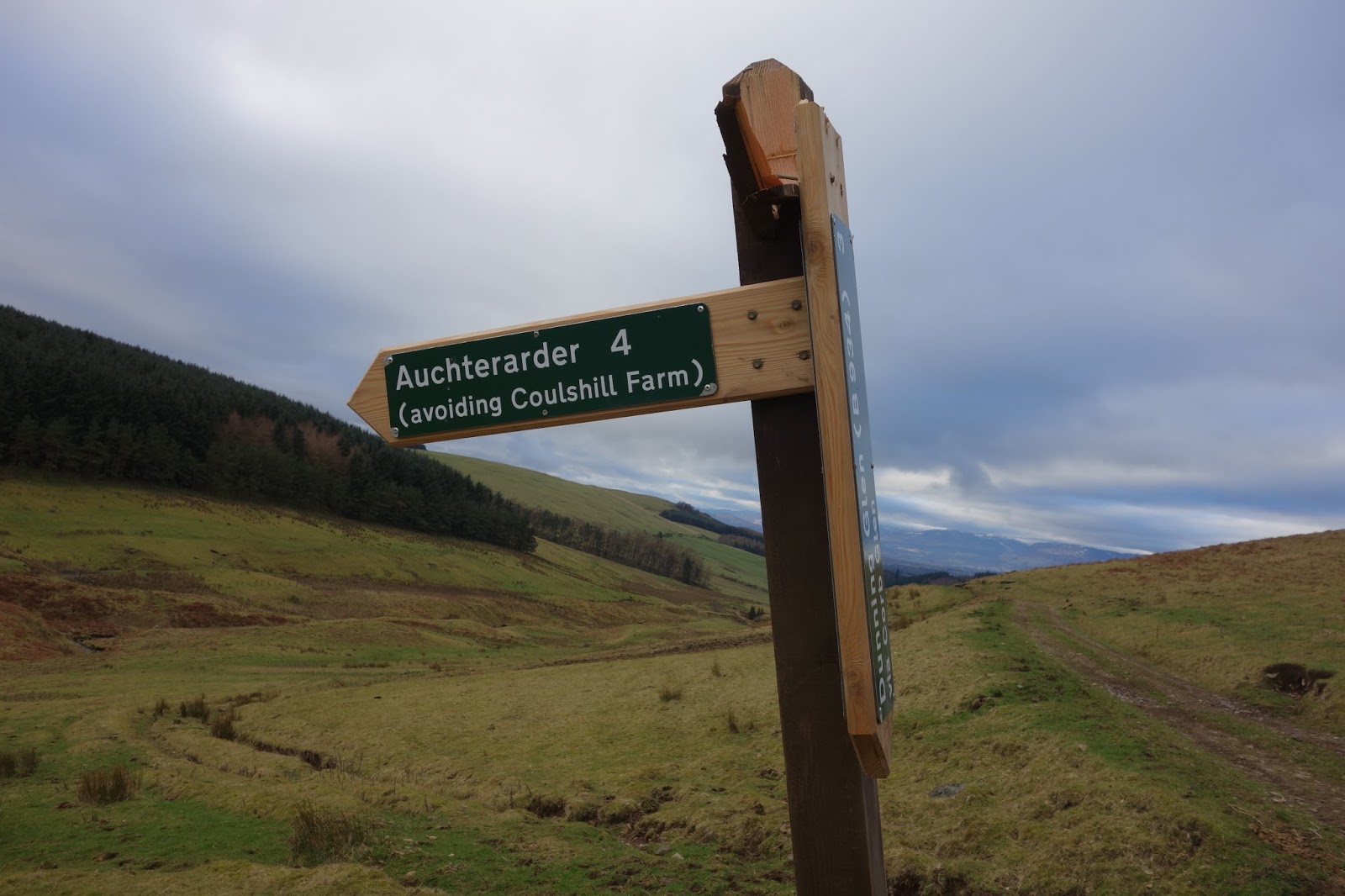
Our day out having been thus shortened, Lynne suggested we wander through the Glen to the point above Coulshill Farm where the RoW from Glendevon to Auchterarder descends to meet our route.

The new sign was damaged. Note the 'avoiding Coulshill Farm'.


I suspect this was damaged on purpose. Perhaps more evidence of hostility to walkers. Note the ghastly Greenknowes Windfarm

We went no further and enjoyed a leisurely stroll back to the car. Somewhere along the way, I lost my sit mat.

Not a good day for photos but click to enlarge if you wish.

A circuit would have given a slightly longer day